Category Archives: Student-led

Teaching Spatial Thinking with Abductive Reasoning

By Joseph J. Kerski, University of Denver and Esri.


Abductive reasoning (also called abduction, abductive inference or retroduction) is a form of logical inference that goes from an observation to a hypothesis that accounts for the observation. It ideally seeks to find the simplest and most likely explanation. In abductive reasoning, unlike in deductive reasoning, the premises do not guarantee the conclusion. One can understand abductive reasoning as “inference to the best explanation”.  The fields of law, computer science, and artificial intelligence research have renewed interest in the subject of abduction.


Abductive reasoning can be effectively taught through spatial thinking and analysis with the use of Geographic Information Systems (GIS) technology and methods.  Through the overlaying, swiping, and display of maps and imagery in a GIS, students are encouraged to make observations about the patterns, relationships, and trends, or lack of pattern.  They can then form a hypothesis about why the pattern exists and how it came to be.  They can then test that hypothesis against the data, by running a set of spatial statistical techniques, by testing different models, by symbolizing and classifying the data in different ways, and by examining different regions of the world at different scales, testing whether the relationship holds in all regions and scales, or just some.

All of this is what I find most valuable about teaching with GIS–it is one of those few tools that allow for inquiry, investigation, hypothesis testing, changing the variable(s) analyzed, all in one environment.  In fact, GIS was created to be that very thing—a toolset that would allow problem solving and investigation.  I like to think of GIS as a means of enabling students to investigate the “whys of where”.  These investigations can occur at the local level, where hypotheses could include “Food stores in my community will be geographically dispersed, while antique shops will be more geographically clustered, “ or, “There is a positive correlation between median age and median income in my community.”   But the questions can be in an optimal location style, such as, “Where is the best location for an urban greenway in my community?” These questions can occur at the regional scale, such as “How have the land use patterns changed in the past 25 years, where have they changed, and why?” and at the global scale, such as “What is the pattern of earthquake depth and magnitude in close proximity to plate boundaries?  What is the relationship between birth rate and life expectancy, by country, and what is reason for the patterns that I see?”

As we begin examining the data, I find that it is best if the students give a hypothesis. In one of the examples above, I ask students to state what they hypothesize the pattern of global earthquake magnitude related to the major types of plate boundaries to be, and then do the same thing with global earthquake depth. I also ask them to state why they stated their hypothesis that way. What components of past geographic knowledge are they bringing to bear on their hypothesis, or are they truly “in the dark” about this specific type of spatial relationship without prior knowledge?

With today’s web-based GIS tools, students can visualize and analyze real-world phenomena in 2D and 3D, and increasingly in real time.  They can collect their own data with smartphone apps with their own equipment and then map and analyze that data.  They can communicate their results with web mapping tools such as multimedia story maps and share these maps with others.  I find that students think holistically about problem solving through the use of these tools.  Through these web based GIS investigations, students also must deal with issues such as data quality, data volume, scale, location privacy, crowdsourcing, and the proper use and citation of web images and data.  They must also think about which maps that they should share with the public, which maps they should share with a smaller group such as their own research colleagues or classmates, and which maps they should not share at all.

Consider this example that I have taught with many times from secondary school to university level.  After examining the types of crops grown in the USA, and after conducting research on the type of climate and the amount of precipitation that is required for cotton, students hypothesize about where cotton will be grown.  They then observe the pattern of cotton production on an interactive web map.  They note that their hypothesis was confirmed, at least in part:  Cotton exhibits a southerly pattern:  Thus, latitude does matter.  But although some of these southerly areas receive enough precipitation, others are semiarid.  How can cotton be grown in these semiarid regions?  After further investigation, students discover that irrigation from river diversion makes cotton production possible in southern Arizona and irrigation from deep groundwater extraction makes cotton production possible in west Texas.   Students then begin to ask, “Should cotton be grown in these semiarid areas?  Is this the best use of natural resources?”  At this point, the students, not me, are driving the inquiry. In the best spirit of geographic inquiry, student investigations lead to additional questions, and the investigation continues using the web maps as one of the tools of study.  Thus, the map layers and the GIS tools are means by which the students investigate the issues.  The maps are not used merely to find “where” but help students understand the “whys of where.”  And they help move students forward in their thinking from “what are past and current patterns” on to “what would be the best plan in the future for this community, region, country, or global phenomena.”  Thus they use the tools to envision a better and more sustainable future.

Consider another example below from a GIS-based investigation:  Say after observing the map of ecoregions and population density that I created online, that the student’s hypothesis is that the savanna regime division is generally characterized by higher population densities in the region of East Africa.  Then, students investigate such questions as:  “Does the savanna suffer from biodiversity loss to a greater degree than less populous ecoregions?  What are other factors that can help explain the pattern of population density in this area? Is it topography, water availability, proximity to roads, agricultural production, or some other reason?  If I zoom in to a larger scale, does the population density remain higher in the savanna than other ecoregions at that larger scale?  Why or why not?  What are the long term implications for the ecoregions in this area?  How do these patterns compare to those in other regions, including the region in which I live?  How can I use what I have learned to make wiser decisions about land use and ecoregions in the future?”

How have you used hypothesis testing and abductive reasoning in your own teaching or your own research?

kerski


The Field Trip and the ‘Occupation’ of Outdoor Educator: developing a place responsive approach to professional development in HE

By Danny Towers (University of Cumbria) and Dr Chris Loynes   (University of Cumbria)

 Place responsiveness in outdoor education is a big topic. It became more urgent for staff at the University of Cumbria when we were faced with an international cohort of masters students. The last thing we wanted to be accused of was a neo-colonial teaching of the British ‘way’ leading to the emergence of a globalised practice in places as far-flung and as different in their landscapes and cultures as Columbia, Kazakhstan and the Philippines.

But is it possible to overcome all the traditions, training and expectations of the UK’s iconic outdoor education practices, from adventure activities to environmental sciences, in order to develop a practice largely inspired by the place itself? We took inspiration from Quay and Seaman’s recent book ‘John Dewey and Education Outdoors’ in which they propose Dewey’s concept of ‘occupation’ as an organising principle for a curriculum. We then took the students to a remote (in English terms) valley and posed them the question ‘what kind of outdoor educator could you be here?’

The field trip design

We chose the valley of Ennerdale because as England’s first rewilding project it is already challenging the norms to be found in English landscapes, their appearance, the activities that take place and the way it is managed. We hoped this would give us a head start in challenging any expectations the students might have about how outdoor education ought to be practiced.

After outlining examples and critiques of British outdoor practices being adopted abroad we asked the students to think of the kind of outdoor educator they felt they wanted to become in this place. The intention was to encourage the students to explore the valley, notice their own talents, interests and motivations and consider these in the wider context of their cultural ideas of educational purpose. This, we hoped, would lead them to explore what knowledge and skills they needed so they could be helped to become that particular outdoor educator. The students’ prior experience of what an outdoor educator should ‘look like’, if they had any, is significant in this instance, and, likewise, their emerging understanding of Ennerdale. The important thing to us was to raise awareness of these influences so that the students could balance the three influences of the place, their own interests and talents and the ideas of nature based education in their cultures of practice.

cl-blog-041016-picture-1

  1. A sensory exploration of the valley at different scales

Dewey’s concept of occupation

‘Occupations’ are not simply about vocational learning. Dewey’s intention was to connect ‘education’ to the ‘occupations’ of community, family and social life. The experience of ‘occupation’ is holistic in an immediate and aesthetic sense. The concept can be seen as an organising principle, providing a lens through which to explore a wider range of knowledge than typically highlighted in HE.

Historically, teachers as the ‘keepers of knowledge’ or the ‘expert’, determine what particular knowledge learners need to know. We hoped ‘occupation’ could help to change these power relations. We anticipated that the experiential doing and knowing would engage the students in using their experience to construct knowledge valid to them and give their sense of place a voice socially and, ultimately, professionally.

In seeking to develop a place responsive education outdoors we wanted to put less emphasis on the ‘occupation’ as defined by the professional world and to foreground the place, its landscape and culture, together with the individual professionals and their values and interests in determining the form the ‘occupation’ took. To our minds this could produce a more place responsive approach and a more politically engaged education.

cl-blog-041016-picture-2

  1. Examining the new woodland from the perspective of the rewilded cattle

What happened

Initially, the students developed a long list of knowledge and skills drawing on their experiences and imaginings of what an outdoor educator did and why. This list was challenged by us to bring it down to skills and knowledge that could be developed in this place, an affordances approach. This led to an exploration of the valley and the hills around on foot and by canoe. The river, the lake, the forest and the surrounding hills became the centres of attention as students explored them and, in many cases, developed new skills in order to do this. The night became a focus of interest, either around the fire, on night walks or on overnight camps out in the forest, a first for a number of students. Interests were diverse.

At one point we watched a group of students at a gorge in the river. People were picking blackberries for supper, bouldering on the rocks of the gorge, swimming and jumping into the plunge pools, chatting by the riverside and sharing a way to listen to the sound of the river as it flowed underwater using the stems of nearby rushes. Meanwhile others were exploring how far they could walk round the mountain ridge surrounding the valley and others were learning to canoe sail on the lake.

cl-blog-041016-picture-3

  1. Exploring the rewilded River Lisa from the river’s point of view

Students were exploring how to engage with the valley temporally and spatially. They developed a wide range of approaches inspired by each other, the skills and knowledge of the staff and the valley’s material presence. Engagement was sensual and embodied rather than intellectual. Social opportunities were often a central focus although some solo walks and overnight camps did take place.

What, to us, was missing was a way to engage the students with the deeper environmental knowledge, and social and political aspects of the valley, the knowledge held by ‘experts’ such as the rewilding officer and the farmer. We were only encountering the valley through a narrow lens. Orchestrating these other views in a short time frame and without assuming our mantles as experts was challenging.

A walk and talk with the rewilding coordinator began to develop a deeper interpretation of the valley beyond the material encounter. Moving through the forest following the trails created by the herd of almost wild cattle and wading upstream in the unconstrained river were powerful experiences brought fully alive by the observations of the rewilding coordinator who had the perspectives of time and a larger purpose. She could point to the green fuzz of regenerating trees or tell how, in the last heavy rainfall, this valley was the only one not to flood as the water was held and released in the naturalised valley so much more slowly. She could stand with us on the riverbank and tell the story of how the removal of a bridge had caused the return of several species of fish to healthy populations now their spawning grounds were restored. One such critically engaged encounter opened the door for further explorations of the knowledge about the valley held by others.

cl-blog-041016-picture-4

  1. Finding time to be with the forest and its other inhabitants

Conclusion

Our instinct was perhaps right in that a different outdoor educator can emerge when the norms of practice are withheld. The approach was successful in problematizing the ‘occupation’ of outdoor educator amongst the students. They reported that it helped them to explore their own interests more confidently throughout the remaining two years of the degree programme and to be alert to their personal, professional and cultural contexts. Time seems crucial to us. Place responsive outdoor educators needs to experience a landscape in space, over time and with others to develop their own ‘occupation’.

cl-blog-041016-picture-5

  1. Telling the geological story of the valley from the pebbles in the river

cl-blog-041016-picture-6

  1. Tales of the forest – the human interpretation

Quay, J., & Seaman, J. (2013). John Dewey and Education Outdoors. Rotterdam, Netherlands: Sense Publishing.

Acknowledgements.

The MA Transcultural European Outdoor Studies is an Erasmus Mundus MA provided in partnership by the University of Cumbria, the Norwegian School of Sport Science and Marburg University. This blog is partly based on a presentation made at the HERG session at the 2015 RGS International Geography Conference at Exeter University. Photo credits: Chris Loynes

Reading Landscape – a collaboration between Geographers and Artists

By Hope Barraclough, Anna Bond, Felix Hall Close, Lucy Ewers, Alexander, Hitchinson, Joanna Hooper, Anna Monkman, James O’Connor, Flora Parrott, Leonie Rousham, Greta Sharp, Dr. Mike Smith, Robin Tarbet, Issy Veysey, Anna Vlassova-Longworth, Stanley Welch, Natalie Wyle

‘Reading Landscape’ is a collaborative project between Kingston University Geography and Fine Art students.

Picture Flora Parrot

Dr. Mike Smith (Department of Geography and Geology, Kingston University) and Flora Parrott (Artist in Residence at the RGS-IBG Collection 2016 and Fine Art Department Kingston) invited students from both departments to respond to the concept of ‘Reading’ a landscape or an environment and to develop an individual method of collecting data.

Central to the collaborative work was the use of a site or location as a focal point: it would be viewed and analysed through the “lens” of each discipline. In doing so the group would have a new perspective on their methodologies, recognise parallels between what initially appear to be polar disciplinary approaches and understand how methods of teaching and learning can be expanded and challenged through collaboration between fields.

After an introduction to the brief in the Fine Art studios, selections were made from proposals submitted by the students and in March 2016 the group began to meet regularly to discuss methodologies and definitions.

A selection of potential sites were proposed and the Grand Entrance Hall to the Thames Tunnel at Rotherhithe selected. This chamber, on the banks of the Thames, was designed by Marc Brunel and opened in 1843. It is a space with visible traces of it’s past on the walls, an evocative interior, suburban, location starkly different from the surface level at which it is accessed. The group developed plans outlining how the wide-ranging ‘data’ might be collected and pooled in order to develop a collaborative response to the site.

On the field trip to the Grand Entrance Hall the group had limited time to collect their data. The techniques used included sound recording, frottage, pin-hole photography, plane tabling, photogrammetry, poetry and drawing.

“Whilst in the shaft I observed and recorded the different range of activities going on in the space. It seems the breadth and depth of different people’s interpretations and readings will be vitally important when reviewing our time there and trying to retell and interpret the space as we remember it.” Anna Monkman, Fine Art student

The day was energetic and dynamic, the students were fascinated and possibly slightly intimidated by each others’ techniques. The results were recorded on a blog (http://rotherhitheshaft.tumblr.com/) which became the foundation for a follow up workshop in the Stanley Picker Gallery in May 2016.

During the workshop we had the opportunity to reflect on the site visit. The students had become more familiar with each other by this point and felt more able to ask direct questions about the processes used in the space without feeling that lack of knowledge in another field was a barrier.

Fine Art practice encourages ‘thinking through making’ and so in this spirit the students worked on small tasks in break out groups for the afternoon. The tasks had no specific rationale but in carrying them out space for discussion was created. For example, one group took the results from the plane tabling and used them to map the Grande Entrance Hall at 50% scale in the gallery car park. During this time we overheard conversations between students about the importance of practical application and field work in both disciplines. Another task was to map a section of the 3D photogrammetretric model on to the wall in the gallery space using the point cloud data. The pipe from the wall was detached from the model and simplified – this became a pivotal discussion in the making of the final short film and also presented a challenge for PhD student James O’Connor who found new ways in which to work with technologies that he uses on a daily basis.

“Within computer science a very typical task undertaken is to try and structure data by dividing it’s contents into various groups sharing some common information (classification). In the case of the shaft, this task can be done manually as it’s not a huge amount of work, but during the discussions yesterday I noted a few people interested in the fact that science looks to always patch out errors, whereas artists can embrace them.” James O’Connor PhD Geography

This type of exchange, although difficult to quantify, helped both staff and students to deepen their understanding of their own approaches.

One of the most profound conversations to emerge from the site visit was around our own personal metrics and gauges and how they alter our perceptions of space. Leonie Rousham (Kingston Fine Art Foundation) instructed us all to measure our bedrooms prior to the field trip and to then reapply these dimensions within the Grand Entrance Hall using tape on the floor.

The non-exacting and elusive ways in which we a perceive space as individuals is the central theme of the short film. The ideas that we bring to bear, employ consciously and sub-consciously and merge to form our own set of parameters are key to our response at each and every location and that this is uniquely formed encompassing and employing the historical dimension that is embedding there. The tensions between these streams of information are what the project attempts to make transparent.

In the final meetings about the film, the group discussed the site and how to combine the readings; there was no sense of hierarchy or of ownership, it was simply about how best to communicate the sense of place and to include as much of the information as possible. There was very little discussion about the differences between Geography and Art practice, instead there was a sense of symbiosis and shared intent.


Whose voice is it anyway: Delivery and Development, what’s the difference and why does it matter?

by Rachel Hunt, School of Geographical and Earth Sciences and Victoria Smillie, Institute of Health and Wellbeing, University of Glasgow

This blog post came about as a result of a postgraduate teaching session at RGS 2015. There, and now here, we have sought to share our views about the importance of the role of the GTA within courses which they help to run.

Those academics engaging with the problem of the GTA recognize that from the GTA perspective there are many positives to our awkward role within the department. Not only does this work boost our wages, communication skills and employability’s (so they tell us), but more importantly provides a much needed break from the solitude that the PHD can bring.

However, Despite advances in the appreciation of postgraduate efforts, and the acknowledgement that GTA’s make up a significant part of the undergraduate teaching team in most universities, the picture is not of universal progress and Linehan’s (1996:107) comments regarding the ‘low grumbling murmur’ of postgraduates continue today. Indeed we can see papers by Linehan (1996), Muzaka (2009), and Park and Ramos (2002), among many others who lament the underpaid, undervalued and under recognised work that many GTA’s undertake.

Many authors report on the specific role of the GTA in shaping courses arguing that we GTA’s should have a role to play in course construction. Yet we are left wondering where to find the time to continually provide and update the courses on top of our phd work, our requirements to publish, to do out reach work, to attend, organize and speak at conferences. The pulls on a researchers time are endless.  As such it is not only diligence above and beyond the call of duty (or scope of payment) which is often expected in terms of GTA involvement, but we would argue that ‘we’ as a cohort are not given the full experience of this ‘apprenticeship’ to use Beesley’s (1979) term.

Despite this, very few authors provide an insight into the messy, in-between status of the GTA, nor really provide any helpful guidance as to how we might redress the balance between wanting to impact upon the courses upon which we tutor, demonstrate or lead, and keeping to our 3 (erm, 4 in our case) year deadline.

Therefore, our aim at RGS and within this blog is not only to voice some opinions from those GTA’s working within the university of Glasgow but also to discuss our own experience of creating a new level one introductory lab. In doing so we aim to make the argument for, and present one example of, the way in which PhD teaching assistants can be given a voice through involvement in the development of teaching materials. Through this we aim to ask questions of delivery and development, focusing on those questions voiced in our title, what’s the difference and why does it matter.

Now, lets hear from 5 of our fellow GTA’s at the university of Glasgow. (available here)

The views expressed here corroborate those within the literature recognizing both the positives and the negatives. Unlike many other departments however we often do have input into our courses. Working as part of the level 1/2 team we receive detailed outlines for each tutorial but these outlines also give points at which we can depart from the written word should our own experiences as researchers be more relevant.

Further to this a team of three GTAs (of which we are two), were given the opportunity to redesign course material for the level 1 introductory lab class, paid of course, giving us an undeniably invaluable opportunity for our voices to be heard. The offer for this opportunity was put out to all of the GTA’s in our department to work in groups to change any one part of the level 1 or 2 course. This amounted to any lab, tutorial or lecture. We were lucky enough to be chosen with our proposal to change a slow and dreary lab which had existed since many of the group were undergraduates.

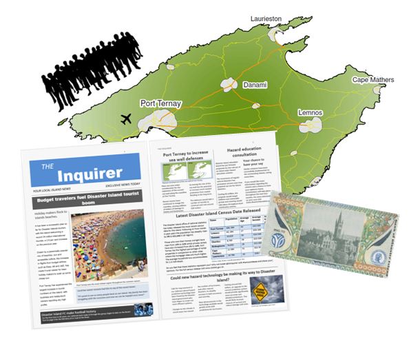
And with this we created Disaster Island and a two hour task to save the lives and economy of those living on this hazardous place. The lab takes the form of a real time game where students are put in teams, and set to complete a number of hazard based choices. They are given money, people counters, press examples, and maps to aid these decisions.

Glasgow a

This lab aims to encourage students to get to know to each other, get used to the lab environment and appreciate the unique qualities of geography in it’s ability to incorporate human and physical elements.

The process of creating this lab was an enjoyable one. As the images below show, the process started with blue sky thinking, and was gradually narrowed down to include reality or at least a more realistic approach to creating lab materials. We learnt about the practicalities of creating teaching materials, the timescales involved and how to incorporate such work into an existing course, complimenting what was already involved in the level one course while also bringing in brand new material  and with that adding our voice. This was about a new tactile experience, which deviated from the traditional academic process of knowledge exchange, in our department at least.

Glasgow b

We would therefore encourage other university teachers to provide these opportunities within their own institutions, not only for the students, but for the GTA’s themselves. Opportunities such as the one described remain few and far between. It simply would not be economical for universities to offer these opportunities to all willing GTA’s within the department, nor practical to fully redesign courses each year in order to provide these chances.  But this represents an important way to recognize and respect the knowledge, enthusiasm and skills held within the GTA cohort. It is key for us to stress that our immediate, and award winning, teaching team do make us feel like we have a voice, and are not just a face of the department.  However, it is still fair to say that department wide recognition of the teaching team as a whole sadly appears to be generally undervalued. In order to establish a significant role for the GTA within departments it is important to provide opportunities and support for the development of those courses on which we are trusted to teach, a trust we do not take lightly.

What we are talking about with regards to our experience in the development of materials is not the finished article, not by any means, the involvement of the GTA voice could, for sure, be taken further.  Rather our suggestion is a movement towards increased appreciation, rising satisfaction, improved deployment and ultimately better departments which properly equip us for the profession in which we have made our first steps. We worry that failing to do so will continue to allow dissatisfaction to roam like monsters on maps of old. (Linehan 1996:107)

References:

Linehan D., (1996) ‘Arena symposium: teaching assistants’, Journal of Geography in Higher Education, Vol. 20. pp. 107-117.

Mazaka V., (2009) ‘The niche of Graduate Teaching Assistants (GRAs): perceptions and reflections’, Teaching in Higher Education, Vol. 14, pp.1-12.

Park C., Ramos M., (2002) ‘The Donkey in the Department? Insights into the Graduate Teaching Assistant (GTA) experience in the UK’, Journal of Graduate Education, Vol. 3, pp. 47-53.


Intrepid Explorers: sharing experiences and learning from field research

By Kate Baker, Briony Turner , Faith Taylor (King’s College London, UK)

Last week, Intrepid Explorers participated in the 2015 Annual Conference of the Royal Geographical Society, contributing to a session sponsored by the Higher Education Research Group, exploring the ‘University in the Anthropocene: Higher Education and Community Engagement in Environmental Management’ chaired by Rebecca Farnum, King’s College London. The session focused on how learning can be transformed by having multi-tiered education and encouraging knowledge exchange between the University and its community. Tim O’Riordan, University of East Anglia, the key note speaker for the session, described these projects as helping to give students a passport for life equipping them with transferable skills beyond the realms of academia. This holistic view of higher education is something that Intrepid Explorers believes in strongly. As a student led educational activity of the Department of Geography, King’s College London (KCL), we believe that by sharing experiences and learning from field research, it is possible to inspire current and future generations to support and advance science.

Intrepid Explorers started in 2012 when PhD students realised that academics and students, within the KCL Department of Geography, travel all over the world to conduct field research but on return disseminate only academic results, with little spoken about the experiences and stories behind the field research. Intrepid Explorers is a platform set up by, and run by, students to create and facilitate a space for the researchers and guests of the department to communicate life as a field researcher in a manner that is accessible to all. Initially set up as a weekly seminar series, it proved to be successful in engaging students and staff from all research groups, along with the general public. The seminar series has now been running for three years and is embedded within the research activities of the department. In 2015, Intrepid Explorers expanded from a lunchtime seminar series, to a student led platform organizing a range of educational activities including documentary film screenings, evening talks and microadventures. The department recognises the contribution these activities make both internally and externally, providing formal recognition as well as financial support for the activities.

Intrepid Explorers creates a space for conversations between researchers, from different groups, and universities. Collaborations and interdisciplinary projects have stemmed from Intrepid Explorers’ seminars and activities. One example, is a discussion that started after an Intrepid Explorers talk which resulted in a collaboration between the Fire research group at KCL and Zoological Society London (ZSL) – which led to a NERC funded PhD project. The PhD student, Jake Simpson also made use of an opportunity to use drones for research, circulated to research staff and students by Intrepid Explorers.

Aside from research, Intrepid Explorers has engaged with the student community, enabling them to gain the necessary skills, through workshops and microadventures (or simply the confidence!), to venture out on fieldwork. This has resulted in a record number of students in the KCL Department of Geography applying for the Royal Geographical Society’s Geological Fieldwork Grants (GFG).

Engagement with the wider community is becoming increasingly important in universities and is something that Intrepid Explorers supports and promotes through running public outreach events. These events are usually attended by ~150 people and include A-level school groups, learned societies, interested individuals and academics from across London and beyond. Educational material related to these events has been used in six schools as case studies for A-level and GCSE Exams and events have even been repeated. A Head of Geography from Wimbledon High School repeated a replica of one event, which included the documentary ‘Chasing Ice’ with a framing talk by Prof. Mike Hulme.

Participating in the workshop on the ‘University in the Anthropocene’ was extremely useful for Intrepid Explorers. It was valuable and stimulating to hear about other projects that link Universities and the wider community including ‘Bright Futures’ presented by Cherish Watton and the ‘Integrating International Volunteerism’ with Oriel Kenny and Susan Robinson from Leeds Becket University. In addition, Marisa Goulden gave a thought provoking talk on transformative learning in Universities which included consideration of the relationship between field based research and its impact upon the health and wellbeing, particularly the emotional response, of academic staff and students. This is something that the team at Intrepid Explorers has long been interested in, particularly due to inspirational past talks by Lloyd Figgins, Wim Nijssen and Dr Frances Cleaver that have incorporated preparation of, and maintenance of, mental health and wellbeing in the field, so potential for future collaboration!

Finally, the Intrepid Explorers conveners were encouraged by the interest demonstrated by a number of participants during the workshop in starting Intrepid Explorers in their respective universities. We’ve developed a wealth of knowledge from our experiences and are happy to share the branding and guides we have developed so that other universities can hit the ground running! Just get in touch intrepidexplorerskcl@gmail.com.

Many thanks to the chair and convenor, Rebecca Farnum, for an excellent session and to the Higher Education Research Group for sponsorship!